The Family on the Map, 1877
In 1877 a county atlas lettered forty-one of us across Norfolk. Read beside the land registry, it shows what three generations made of a thousand acres, and why one son left.
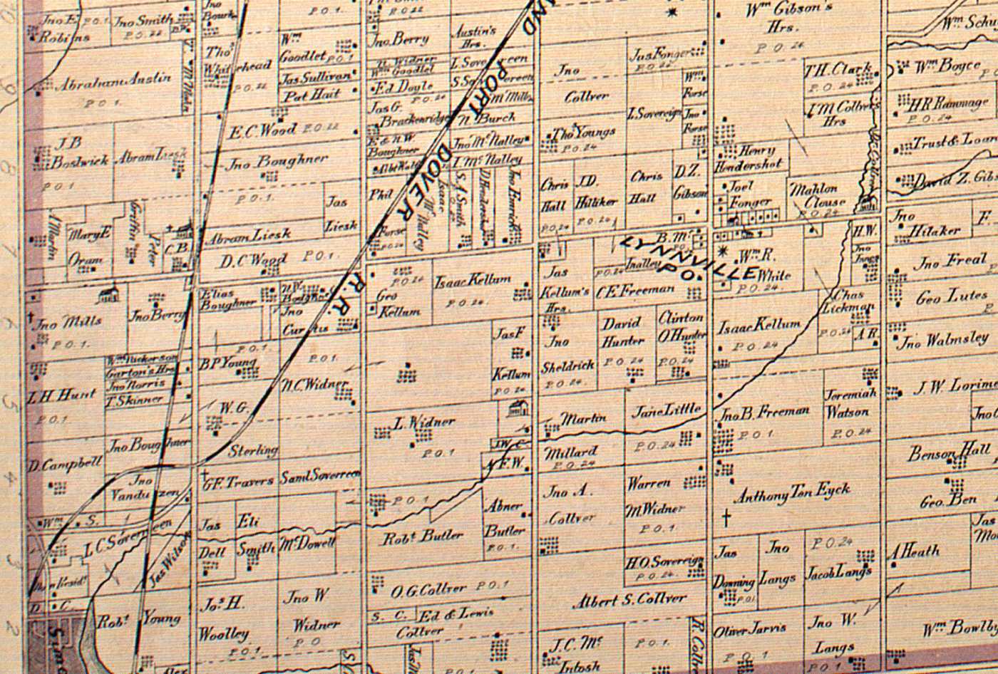
A concession, in the Upper Canada survey, was a strip of land running the width of a township, and a lot was one farm-sized piece of the strip, usually two hundred acres. The words did the work of a street address. A settler lived at Lot 1 in the twelfth concession of Windham, and a clerk in a registry office a century later could still find him there. Where a township met the lake and the strip came out short, the surveyors called it the broken front. Where two surveys failed to meet squarely, the wedge left over was a gore.
In 1877 the Toronto firm of H. R. Page and Company put all of it on paper. Their Illustrated Historical Atlas of the County of Norfolk gave each township a lithographed sheet, concession by concession and lot by lot, with the owner’s name lettered across his land. It was sold by subscription to the farmers it pictured, and it shows a county at the moment its people wished to be seen.
My family is on five of those sheets.
Forty-one names
Count them through the index that McGill University has built to the atlas, in all three spellings, and the Norfolk sheets carry forty-one of us: twenty-four entered as Collver, three as Colver, fourteen as Culver. Forty of the forty-one are mapped to land. The other is the township clerk of Townsend, who is listed for his office. Windham has nine, Townsend twenty-two, Charlotteville four, Woodhouse five, and Walsingham one.
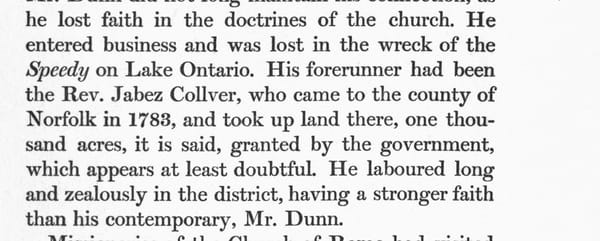
Eighty-three years earlier there had been one. On 14 June 1794 the Executive Council of Upper Canada answered the petition of the Reverend Jabez Collver, my sixth great-grandfather, with an order for a thousand acres in his own right and two hundred for each son who had come in with him. Readers of this blog have met that order before. The atlas shows what three generations made of it.
It would be easy to look at forty-one names and say the family had prospered. Many of them had. Loder Culver, on the Townsend line, farmed three hundred acres and made cheese. But the atlas letters something else beside the names, and the index gives it in figures: a hundred acres, seventy-five, fifty, twenty-five. One Culver in Townsend holds ten. In Windham there is a fifteen-acre piece marked only “Collver,” with no first name at all, as though the engraver had run out of people to give it to.
The homestead, gone to the heirs
Take the homestead lot. Lot 1 in the twelfth concession of Windham was the ground of the 1794 petition, the place where Jabez kept the Sabbath in his own house and where the Old Windham church later stood. In July 1804 he sold it to his son John, bought part of it back the next spring, and sold that to his son Gabriel in 1806. He spent his last years under Gabriel’s roof, a patriarch in residence and no longer a landholder.
When the schoolteacher John Earl walked the county about 1855, he found Nelson Colver on the lot, Gabriel’s son, with a neighbor on the other part. That is the third generation, and the lot is still nearly whole. On the atlas sheet of 1877 the same corner of Windham reads like a seating chart. O. G. Collver has a hundred acres. Edward and Lewis Collver share one lettering across two lots. Albert S. Collver sits beside them, John A. Collver beyond him, and an R. Collver is tucked against the township line. All are cousins, and none holds much more than two hundred acres.
Nothing went wrong on that ground. No one lost the farm, and no bank took it. The land divided because the family divided it, among sons, at each death. The lawyers call that partible inheritance, division among all the children in place of descent to one, and it had been this family’s habit since New Jersey. A thousand acres is a kingdom in the first generation and a competence in the second. By the fourth it is a quarter-lot and a decision.
One name, followed through the registry
The atlas is a photograph. It tells you who stood where in 1877 and nothing about how he came to stand there. For that there is the land registry, whose abstract index lists every deed, mortgage, and discharge ever registered against a lot, in order. I have followed one name through it.
On the Charlotteville sheet, on a narrow strip at the top of the third concession, the engraver lettered “Wm. Collver.” That is William Valentine Collver, my third-great-grandfather, the eighth of eleven children of Jabez B. Collver, who was the Reverend’s grandson. The index gives him thirty acres there, on Lot 24, and a hundred more on Lot 20, with his post office at Vittoria.
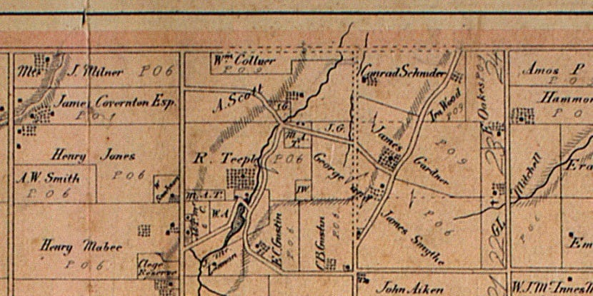
His father had died in 1841 at Woodhouse, on Lot 1 of the broken front. The assessment of 1850 found the widow, Hannah, on the north part of that lot with fifty acres cleared and a frame house. She died that June. When Earl came by five years later there was no single owner to write down, so he wrote “Culver Family and others.” That is eleven heirs and one farm. William was twenty-five and held no land that any record shows. The census of 1861 calls him a mechanic, which then meant a builder.
His name enters the registry in November 1865. The abstract for Lot 5 in the broken front of Woodhouse, four lots along the lake from his father’s farm, shows his older brother Festus and a neighbor named Frederick Sovereen holding ninety-three acres together. Sovereen sold his undivided half to William. The two brothers then traded deeds, each releasing his claim on the other’s part, which is how an undivided half becomes a farm with a fence around it. William came away with forty-six and a half acres, and on the day the deeds were registered he mortgaged them to Edwin Gilbert. He had married Samantha Gilbert seven years before.
The clerk who entered those four deeds spelled the family three ways in four lines. Festus is Colver in one line and Collver in another. William is Culver in one and Collver in the next. An early post on this blog took up that very question. The registry had already answered it in 1865: all three, and no one minded.

In January 1868 the mortgage was discharged, and the same day William sold Edwin Gilbert nearly twenty-eight of the acres. In February 1874 he and Samantha sold what remained, eighteen and a half acres and a few square rods, to a neighbor named Daniel Woolley. Add the two sales together and they come to forty-six and a half acres exactly. He had bought the land in one piece and sold it in two, and the abstract accounts for every rod of it.
Three years later the atlas finds him in Charlotteville with a hundred and thirty acres. Festus stayed. The same atlas letters “F. A. Collver” on Lots 1, 2, and 5 of the Woodhouse broken front: the father’s lot, the one beside it, and the half he had divided with his brother.
So the map, read beside the registry, shows one son of eleven who consolidated the home place, and another who started with half of a half-lot, sold it by pieces, and began again in the next township at forty-four. How William came by the Charlotteville land I do not yet know. Earl’s list has an A. Scott on Lot 24 in 1855; William’s sister Malissa had married a Scott; and the atlas still shows A. Scott on the parcel beside his. That is a lead and no more. The Charlotteville abstract will settle it, and I have not read it.
What a map cannot show
A county atlas pictures tenure and makes it look like permanence. Every name is lettered in the same confident hand, the ten-acre man and the three-hundred-acre man alike. What it cannot show is the arithmetic working underneath. William Valentine had six children on a hundred and thirty acres. His son John Milton was a boy of fifteen or sixteen when the atlas was published. Nine years later, in December 1886, John Milton married at Port Dover, and within the year he was farming in Michigan. His father stayed, and died in the Gore of Woodhouse in 1907.
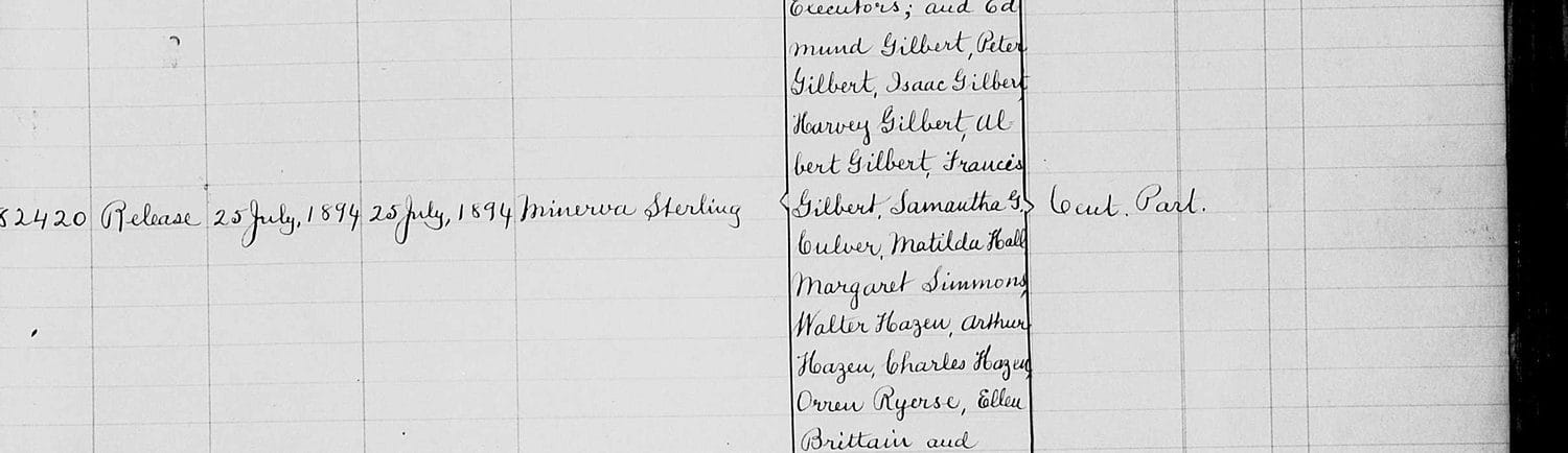
The Gilberts appear once more in the Woodhouse abstract. In July 1894 a release on the same Lot 5 names the heirs of a Gilbert estate, and among Peter, Isaac, Harvey, Albert, and Francis Gilbert the clerk wrote “Samantha G. Culver.” Four of those brothers made their careers in Michigan, as a state senator, a physician, an attorney, and a dentist. The road William’s son took had been laid by his wife’s family.
I do not read the atlas of 1877 as the family at its height or as the family in decline. It is the family at the last moment when most of us could still be found on one county’s map. After it, the names begin to turn up in Bay City, in Sanilac County, in Oregon.
What it means now
The concession roads of Norfolk still run where the surveyors drew them, and the lot numbers of 1794 are still how the land is described in a deed. Anyone with Ontario ancestors can do what I have done here. The McGill index is free and searchable by surname. The abstract indexes are online, at the province’s land registry site and at FamilySearch. Search the atlas for the name, note the concession and lot, and then read the abstract for that lot from the top. The atlas shows where your people were in one year, and the abstract shows when they came and when they left.
For this family the answer was a thousand acres in 1794, forty landholders in 1877, and by the next generation a mailbox in Michigan. The stones at Old Windham stand on the homestead lot, and the cousins who stayed are in the churchyards around it.
Sources.
- Illustrated Historical Atlas of the County of Norfolk, Ont. (Toronto: H. R. Page & Co., 1877), township sheets for Windham, Townsend, Charlotteville, Woodhouse, and Walsingham; indexed in the Canadian County Atlas Digital Project, McGill University Library (digital.library.mcgill.ca/countyatlas). William Collver, Charlotteville Con. III, Lots 20 and 24, is PersonID 105601. The count of forty-one is by the project’s person-entries.
- Order in Council, 14 June 1794, on the petition of Jabez Collver of 11 June 1794 (Upper Canada Land Petitions, “C” bundle; Land Book A, 161).
- John Earl, Sketch of the County of Norfolk, Canada West (Simcoe, 1857; data as of 1855). See the earlier post, The Schoolteacher’s Census.
- Norfolk County Registrar of Deeds, Abstract Index, Township of Woodhouse, Lot 5, Front Range (Broken Front), pp. 22–24: instruments 20932–20936 (registered 27 Nov. 1865), 23946–23947 (27 Jan. 1868), 35976 (2 Feb. 1874, registered 15 Apr. 1874), and 82420 (release, 25 July 1894). Images at FamilySearch, “Norfolk, Ontario, Canada records,” Image Group 008198253, images 21–22.
- Deeds of the homestead lot, 1804–1806, and the 1850 Woodhouse assessment, as abstracted in R. Robert Mutrie’s genealogy of the Jabez Collver family.
- Census of Canada, 1861 (Woodhouse) and 1881 (Charlotteville).
Note added 15 October 2026. A reader rightly reminds us that a county atlas is not a census of landholders. Village lots appear on separate plans, a name lettered on a lot may be the occupant’s rather than the owner’s, and two holders may share a single lettering. The count of forty-one above is the number of family entries in McGill’s index, not the number of Collvers, Colvers, and Culvers who held land in Norfolk in 1877, and “forty landholders” in the closing paragraph is better read as forty names on the land. The township sheets were not limited to the atlas’s subscribers: of the forty family names lettered on the land, only three (Loder, Samuel, and Mahlon N. Culver of Townsend) appear in the atlas’s directory of patrons. The case for subdivision rests on the small parcels the sheets do show, of ten, fifteen, twenty, and twenty-five acres. Any the engraver left off would only make the division finer.
Adapted from the forthcoming book — We Are Doves: Four Centuries of the Collver–Culver Family.
© 2026 Albert B. Collver III · The Collver Family History Project. Original historical documents reproduced here are in the public domain; the research, text, and annotations are the author's. Please cite or link rather than republish.